In the past decade, development pressures on Crown and private rural lands in the Bulkley Valley of north west British Columbia, Canada have increased greatly through Crown timber sales, expansion of a downhill ski resort, environmental assessments for proposed new mines, and applications for rural subdivisions. The community is sophisticated about planning and experienced in protecting the public good. 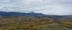 However, Provincial government staff and community decision makers have neither authorization nor time to gather information about largely undocumented public values when processing individual land use change applications. Hence, various new institutions and initiatives have emerged to identify and register valued landscape features in advance of proposals for development.
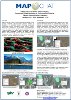
The concept of asset mapping and the MapChat tool were initially introduced to citizens of the Bulkley Valley community primarily through a series of small scale workshops. These workshops were facilitated by community members with GIS and mapping expertise in conjunction with local staff from the provincial Ministry of Environment (MOE). Participants from municipal and provincial government departments, outdoor recreational groups, and the broader community were recruited for the MOE workshops used the MapChat tool to explore various digital map layers assembled from provincial government sources and to augment these data with their own volunteered local knowledge. 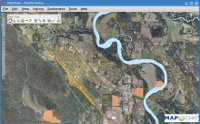 While the participants had the option of recording their assets on supplied paper maps, most opted to use the MapChat tool to select existing features, create new features, record associated comments, and use the software to chat with other participants about features of mutual interest.
These workshops that have taken place between January 2008 and August 2009 have been using the original version of MapChat. In anticipation of ongoing participation in the Bulkley Valley region, MapChat 2 is currently being implemented with data imported from the previous workshops.
Related Publications:
 |
Hall, B., R. Chipeniuk, R. Feick, M. Leahy, & V. Deparday (accepted) "Participatory and Interactive GIS Use in Community Asset Discussion and Mapping", International Journal of Geographic Information Science. |
 |
Hall, B., R. Chipeniuk, & M. Leahy (2009) "A MapChat Co-op for the Skeena Region: Community-Based Geomatics in Environmental Planning", poster presentation, Skeena Salmon Habitat Conference Smithers, B.C., September 15-16 |